The Evolution of Aerial and Drone Photography

Viewing our world from above is a unique experience; it forces our perspective to change. Aerial photography has been used for everything from geographic mapping to artistic endeavors to spy missions, giving people a realistic vantage of the world few had seen before. In the recently released book Above the World: Earth Through a Drone's Eye, today’s top aerial photographers offer vivid displays of color, shadow, and pattern that couldn’t have been accomplished even ten years ago.
Drones have launched a new era in photography and continue to change our view of the world. A drone’s ability to hover closer to the ground that a helicopter ever could has revolutionized photography. Today, the creative potential of aerial photography in a world saturated with eye-level digital images gives artists an edge—without needing to rent an expensive helicopter. Aerial photography via drones is certainly taking off. But where did it start?
The Liftoff of Aerial Photography
Before you could buy drones from the comfort of your desk chair via smartphone, aerial photography was significantly more difficult. Artists and scientists alike used tall buildings, ladders, balloons, kites, planes, and even pigeons to defy gravity.
The very first surviving aerial photograph was taken in 1860 from a hot air balloon by American innovator James Wallace Black. The image depicts the city of Boston from 690 yards in the air. Just two years after this photo was taken, the Union Army would start using balloon photography to spy on Confederate troops during the Peninsular Campaign in Virginia.
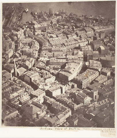
“Boston, as the Eagle and the Wild Goose See It" by James Wallace Black. Metropolitan Museum of Art.
The First Unmanned Flights
About 20 years later, photographers began taking pictures with cameras affixed to kites. These early unmanned flights often required stringing multiple large kites together to elevate their heavy equipment.
English meteorologist E.D. Archibald pioneered kite aerial photography back in 1882 by using an explosive charge on a timer to take photographs from the sky. A few years later, Arthur Batut managed to suspend his bulky camera from a single kite and set an automatically timed exposure with a slow-burning fuse.
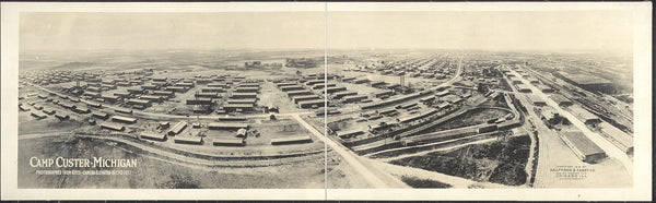
“Camp Custer, Michigan, photographed from kites, camera elevated 500 feet” by Kaufmann & Fabry Co. Library of Congress.
In 1907, German apothecary Julius Neubronner invented the technique of pigeon photography. Neubronner's homing pigeon was fitted with an aluminum breast harness with a lightweight time-delayed miniature camera attached. The cameras took automatic exposures while the pigeons flew. Although Neubronner’s patent application was rejected initially, it was granted in 1908 after he produced photographs taken with his birds.
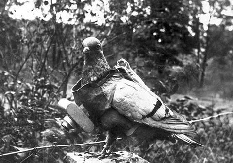
“A pigeon fitted with the pigeon camera.” by Agence Rol. Wikimedia Commons
The Pigeon Corps gathered important intel for Bavarian soldiers—when they weren't shot down by the troops.
Aerial Photography in World Wars
World War I was one of the very first major military conflicts to combine the inventions of aircraft and photography. Reconnaissance aircraft on both sides of the war were equipped with cameras to record one other’s lines and resources to keep up to date with the enemy movements. The sudden need for aerial photography in warfare contributed to several innovations in the field.
Over the course of WWI, the quality of cameras increased so that pilots could use them more easily during flights. By World War Il, militaries were using smaller and faster planes for surveillance. As a result, camera technology improved so photos could be taken at higher altitudes and faster speeds for better intelligence gathering. Allied troops relied heavily on aerial images to plan the invasion of Normandy on D-Day.
Expanding Up and Out
After the war, aerial cameras began to be used commercially. Sherman Fairchild took a series of overlapping photographs to make an aerial map of Manhattan Island. Likewise, Aerofilm Ltd, the first commercial aerial photography business in the UK, carried out aerial photography for survey and mapping purposes. They eventually pioneered the science of photogrammetry: mapping from aerial photographs.
But even then, the sky wasn’t quite the limit. The very first photos from space were taken on suborbital rocket flights in the mid-1940s from 65 miles in the air—five times higher than ever before. By 1963, American astronauts sent the first view of the Earth from the moon back to our televisions.
Today, a camera in orbit can snap a shot of an individual person on the Earth's surface. We've come a long way from kites and camera-fitted pigeons. To shoot the world from the sky today, all you need is a drone, the right equipment, and a little focus—no hot air balloon required.
Share this post


- Tags: aerial photography, drone art, drone history, drone photography, history of aerial photography, photography, tech news, technology