Understanding Climate Change with Drones
Our oceans and atmosphere affect the fundamental processes that drive our weather and the rate of climate change. Understanding these processes is essential, but getting reliable (and affordable) data from remote parts of the ocean and Arctic has been tricky for years. Today, drones aim to change that. From tracking atmospheric particles in Alaskan skies to providing researchers with data on forest planning, drones are playing a bigger role in climate change all the time.
Exploring the Alaskan Atmosphere and How Clouds Form
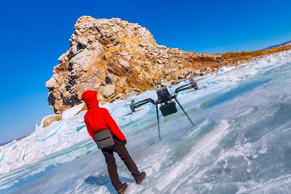
Atmospheric scientists have been using drones for nearly 20 years to take measurements essential to building accurate climate models and forecasts. But flying in the Arctic atmosphere presents unique challenges—at those temperatures, mechanical components require special grease that freezes at lower temperatures. An aircraft would also need to stay warm enough to prevent ice from condensing onto the drone, which could potentially cause the aircraft to crash.
The ArcticShark was born to meet these needs. A team of Department of Energy scientists at the Pacific Northwest National Laboratory commissioned the drone to fly above the Alaska North Slope to capture data from the Arctic atmosphere. The aptly named ArcticShark weighs around 650 lbs and can fly up to 75 mph. It will carry roughly 70 lbs of equipment and enough fuel for eight hours of flight time.
The ArcticShark will measure the size of atmospheric particles, levels of humidity, infrared radiation, and wind direction when it takes off next May in Alaska. The data recorded by the ArcticShark will help atmospheric scientists understand basic but little understood atmospheric processes like how clouds form, which will later be applied to climate models.
Ocean Drones Scour the Seas for Climate Change Data
Saildrones, resembling bright red surfboards, are oceanic drones equipped with 20-foot-high carbon fiber sails and 16 sensors each that test variables from carbon dioxide to acidity to currents and water temperatures. The California-based Saildrone raised $14 million in funding from impact investors last fall. These drones cruise at a leisurely 3-5 miles per hour across the waves and are able to perform work usually reserved for manned research ships for a fraction of the cost.
Saildrones can be operated for approximately 5% of the cost of a manned vessel, helping directly measure and combat the effects of climate change without the traditionally high overhead. These drones have logged over 100,000 nautical miles since their creation.
A total of 20 Saildrones have been deployed on oceanic missions. Earlier this year, the U.S. National Oceanic and Atmospheric Administration (NOAA) sent Saildrones on a six-month mission to the equator to study the weather phenomenon El Nino. Two more sailed for the Arctic Ocean to track ice melt and count seals, whales, and fish. Saildrone also works with NASA to calibrate satellites that measure salinity from space.
Saildrone COO Sebastien de Halleux hopes that with a permanent fleet of Saildrones at sea, scientists would have access to the real-time, high resolution “pulse of the planet.”
Cornell Researchers Measure Albedo with Drones
We’ve known for years that planting forests has a positive effect on our climate. In certain conditions, like locations blanketed with reflective snow cover for long periods of time, however, planting trees can have a warming effect. Charlotte Levy, a doctoral candidate at Cornell University, centers much of her research around determining where to plant forests in temperate regions with seasonal snow cover for the greatest positive impact on the climate.
When making predictions about climate change, it's crucial that researchers understand how much energy the earth absorbs and retains at a given point in time. If the surface of the Earth reflects solar energy instead of absorbing that energy as heat, the result can be local and global cooling. The scientific term for this measurement of surface reflectivity is albedo, one of the main controls for the Earth's overall energy budget. In the past, climate scientists have received albedo measurements throughout the US with satellites and sensors placed on research towers. Unfortunately, there are few of these, and they can’t be moved to compare the albedo of other nearby locations.
Levy and others have developed a new method of measuring albedo using drones with more accuracy and flexibility than ever before. Drones allow measurements to be taken wherever and whenever they’re needed. Researchers today can send a drone to hover over a forest and then have it fly across the road where that same forest was thinned five years ago, allowing researchers to measure any differences in efficiency. Now researchers can look specifically at how management techniques affect forests' overall albedo and adjust forest planning as needed to account for factors that influence climate change.
Share this post